Category
Urban Mapping
Large-format aerial oblique and nadir imaging hardware for wide-area 3D city modelling, used for urban planning, pipeline routing and city-scale digital twin projects.
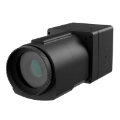
AM150AFJD Trion AM150A Medium Format Urban CameraA standalone 150MP medium-format aerial camera with an interchangeable FJD lens mount, usable independently or alongside the O1 rig.Price on application
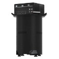
O1FJD Trion O1 Urban 3D ModelingA five-camera aerial oblique imaging payload (1 nadir + 4 oblique, 150MP each) for wide-area 3D city modelling from a drone or aircraft.Price on application